
Mount Rokatenda volcano
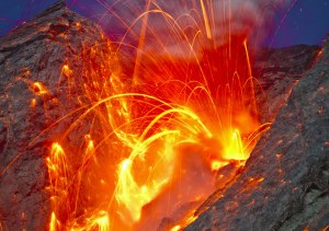
Mount Rokatenda in East Nusa Tenggara province erupted early Saturday morning, and nearly 3,000 people have been evacuated from the area on Palue island.
Click below to watch the eruption!
Mount Rokatenda volcano
Mount Rokatenda in East Nusa Tenggara province erupted early Saturday morning, and nearly 3,000 people have been evacuated from the area on Palue island.
Click below to watch the eruption!
 From the Yadnya Kasada Festival at the crater of Mount Bromo, July 23, 2013.
On the fourteenth day of the Hindu festival of Yadnya Kasada, the Tenggerese people of Probolinggo, East Java, travel up the mountain in order to make offerings of fruit, rice, vegetables, flowers and sacrifices of livestock to the mountain gods by throwing them into the caldera of the volcano.
The festival began in the 15th century when a princess named Roro Anteng started the principality of Tengger with her husband, Joko Seger. The childless couple asked the mountain gods for help in bearing children and, according to the legend, the gods granted them 24 children on the provision that the 25th must be tossed into the volcano as a sacrifice. The 25th child, Kesuma, was finally sacrificed in this way and the tradition of throwing sacrifices into the volcano to appease the mountain gods continues today.
Mount Bromo is an active volcano and part of the Tengger massif, in East Java, Indonesia. To see more photographs from the festival, check out this feature story on CBS!
 I came across this article today from Wired and just had to pass it along…!
“Lo and behold, what do I find but an entire research field that has been making manmade lava for decades. Sure, we’ve seen some of the recent manmade lava flows done at Syracuse University and small-scale lava in experiments for some time, but here I was finding research that involved a ton (literally) of manmade lava … and moreover, these lava have been made by accident on a number of occasions with tragic consequences.”
Corium… Nuclear Meltdown lava. And, I’d like to point out the lovely margin lobation!
Read the full article at: http://www.wired.com/wiredscience/2013/04/the-most-dangerous-manmade-lava-flow/#more-155251
http://www.wired.com/wiredscience/2013/04/the-most-dangerous-manmade-lava-flow/#more-155251
Hey all,
I usually try to keep all of my ‘lives’ seperate and not cross-post, but I’m going to break the rules for today. Below is the video for my latest piano release, “Orbit: A Love Story.”
We spend our lives orbiting around each other. Some days, our gravity is huge and everyone wants to be around… Other days, friends rush away at escape velocity and are gone before we know it… Perhaps, if you are very lucky, you fall into a stable orbit with another and it can only be love…
Love is universal and attraction often fate and gravity.
Think about the piano differently. Better in headphones!
Image Credits: Hubble Space Telescope / NASA / The GigaGalaxy Zoom Project / etc.
Animations created in Celestia
Music available on iTunes/Amazon/ CDBaby /etc.
You have always been here. Bonus points for naming the planet at the end!
Also, check out the “Love & Gravity” Sweepstakes Facebook Page and
enter for a chance to win some limited edition NASA art prints!

Thanks for all the support and positive feedback!! 🙂
Robert Peckyno
“Disaster Zone”, a natural hazards educational resource.
Including:
Enjoy!
Batu Tara
Dr. Tom Pfeiffer, volcanologist with VolcanoDiscovery (an adventure & study travel group that gives tours of active volcanoes) , just posted some amazing photographs from their recent expedition to Batu Tara volcano to observe the ongoing strombolian activity from close range. Really spectacular stuff!
You can view his entire set of photographs and information here.

Eldfell (“fire mountain” in Icelandic) is a volcano on the island of Heimaey in the Vestmannaeyjar archipelago 15 miles (25 km) south of Iceland. Photograph by the late Svienn Eirikksen, fire marshal of the town of Vestmannaeyjar.
There are three main places where volcanoes originate:
The origin of the magma for hot spots is not well known. We do know that the magma comes from partial melting within the upper mantle, probably from depths not too much greater than 100 km. The actual source of the heat that causes the partial melting (the actual hotspot itself) is almost certainly much deeper than that, but we really don’t know how deep or even exactly what a hotspot is!
 At a divergent margin, two tectonic plates are moving apart, and magma that is generated in the upper mantle flows upward to fill in the space. This magma is probably generated at depths that are shallower than those for hotspot magmas. People argue about whether the magma forcing its way to the surface causes the plates to move apart or whether the plates move apart and the magma just reacts to that and fills in the space. Perhaps it is a combination of these two. The most extensive example of this type of volcanism is the system of mid-ocean ridges. Continental examples include the East African Rift, the West Antarctic Rift, and the Basin and Range Province in the southwestern US.


The final major place where volcanism originates is at convergent margins (subduction zones) — where an oceanic plate dives under either another oceanic plate or perhaps a continental plate. As the plate gets pushed further and further it starts to give off its volatiles (mostly water), and these migrate upwards into the mantle just under the overriding plate. The addition of these volatiles to this overriding mantle probably lowers the melting point of that mantle so that magma is generated. Part of the magma may also be generated by the downgoing plate actually starting to melt as it gets into the hotter and hotter interior.

Mount Fuji is famous for it’s perfectly symmetrical cone. This photograph shows the shadow of Fuji projected of the adjacent countryside at sunrise. This photograph, taken in May of 1962, is copyrighted by Robert Decker.
Mt. Fuji is a beautiful example of a stratovolcano, and is almost a perfect symmetric cone (at least when viewed from far away). It is mostly basalt, which is a little bit unusual for stratovolcanoes as most stratovolcanoes are constructed of andesite or dacite compositions. That it is a stratovolcano means that it is composed of layers of both lava and ash. The fact that it is such a beautiful cone probably indicates that it hasn’t recently suffered a big eruption.
“Volcanoes of the World” by Tom Simkin and Lee Seibert lists 63 eruptions of Mt. Fuji since about 9000 years ago. Obviously most of these have been determined by using carbon-14 dating rather than accounts by witnesses. However, the most recent 22 eruptions are listed as having been recorded by people. The most recent eruption was probably the Hōei eruption which started on December 16, 1707 and ended about January 1, 1708. The eruption formed a new crater and a second peak (named Hōei-zan) halfway down its side. Fuji spewed cinders and ash which fell like rain in Izu, Kai, Sagami, and Musashi. Since then, there have been no signs of an eruption.
More great stuff from the researchers studying Monowai and undersea volcanism near Tonga. In a period of less than a month, researchers noted “huge changes” in the height of the volcano – according to a recent article in Nature Geoscience (Watts, A.B., Peirce, C., Grevemeyer, I., Paulatto, M., Stratford, W., Bassett, D., Hunter, J., Kalnins, L., de Ronde, C. & Lamarche, G. 2012. Rapid rates of growth and collapse at Monowai submarine volcano, Kermadec arc. Nature Geoscience)
 This research into the Monowai volcano provides a fascinating insight into the little-known world of submarine geology. You can read more and view a 360 degree model of the changes at this webpage from BBC News
This is the same group that showed us an entire chain of mountains marching to subduction at the Pacific / Indo-Australian plate boundary in 2011. You can read that full article here.

Culmination of the volcano eruption at 21:40 UTC on March 08, 2012. Photo by Yu. Demyanchuk.
Dr. Olga Girina from KVERT sent a message with a link to this excellent website with current pictures from Bezymianny. Very very cool stuff!


